Highway 62 is called the most desolate highway in California. I call it the gateway to the Rice Valley Wilderness and desert Overlanding adventures. It’s a section of the Mojave Desert. I spent 2 days driving my Jeep Wrangler Ecodiesel and Xventure XV-3 off-road trailer through this rugged desert off-road track.
Millions Travel Highway 62 Joshua Tree and 29 Palms - Few Continue And Explore Rice Valley Wilderness
Highway 62 is the main route from Southern California to the magnificent and popular Joshua Tree National Park. Few people will venture past 29 Palms east on Highway 62. The 2 lane road through 100+ miles of desolate desert has no services. There is plenty of interesting things to see if you know where to look.
Train Wrecks, The Rice Shoe Tree and a WWII Desert Training Camp
Heading east from 29 Palms you will pass the Sheephole Valley Wilderness eventually arriving at the the intersection of Highways 62 and 177. 177 will take you south to Desert Center and Highway 10. I continue East to find the Rice Shoe Fence in the town of Rice. Here I turn south on the Rice Midland Road and begin exploring the Rice Valley Wilderness. This is a unpaved but well maintained road (4WD recommended) with awesome views. Rice and Midland are essentially abandoned towns. Awesome isolated drive through the desert.
Finding A Camping Spot In The Rice Valley Wilderness | BLM Dispersed Camping Is My Favorite
By the time I got to Midland the sun was setting and I needed a camp spot. I looked around for a safe location. I try to pick out a place that will not get flooded if it rains and won't wash me and my Jeep away. The awesome views were a bonus.
Midland Vidal Road - The Route Across a Awesome Desert Landscape
Next day I find my route across the desert. A new Overlanding route always gets my adrenaline pumping. Terrain changes on the drive are incredible. The ruggedness is a little intimidating. Thrilling day of discovery from Midland to Vidal across the Rice Valley Wilderness. BLM Website here. https://www.blm.gov/visit/rice-valley-wilderness
Power Lines Often Have Awesome Roads Passing Through Rugged And Isolated Areas
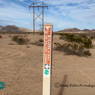
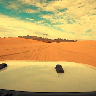
Midland Vidal Road follows a power line access road. These roads and be found all over the West and can be awesome Overlanding routes. This road is well marked with signposts that show a difficulty rating. I went the wrong way into a blind canyon before finding this sign. Used my drone to scout it. See that in the YT video.

Bicyclists Use This Road To Cross the Rice Valley Wilderness?
I was surprised to see a sign saying motorists and bicyclists need to stay in this corridor. Great idea for a video! Overlanding and Mountain Biking could be natural companions.

Don't Want To Be Here When It Is Raining
With steep hills so close to either side of the trail rainwater will come down fast and furious. I could see the evidence of erosion with one portion of the trail washed out. Fortunately there was a way around so I could keep heading towards Vidal. Crossed through many steep washes.
Terrain Changes As I Leave Hills Behind And The Desert Opens Up - Rice Sand Dunes
Still heading north the trail levels out. I was surprised to learn Rice Valley Wilderness has its own set of Sand Dunes. Sand was very soft and it was getting late. I kept my momentum up and decided I would be back to explore the Rice Valley. Sand Dunes
Another Terrain Change On The Midland Vidal Road
Trail looked completely different not far from the Rice Valley Dunes. More mountainous, rock outcroppings and just awesome. Many ups and downs and turns. I saw lots of potentially great camping spots but I was short on time and had to push on to Vidal.

Finally Reached Vidal After A Long Day Of Desert Driving - Wyatt Earp Cottage
After the previous hilly section the trail flattened out and and I crossed a series of sandy washes. Eventually reached the northern end of the trail where it meets the Town of Vidal and U. S. Route 95. The train passes through here and there are a few residences. Not much else.
Solo Overlanding I Saw Nobody - What If Something Went Wrong Crossing The Rice Valley Wilderness?
I did survive my short but awe inspiring solo trip across the desert. My choice of vehicle, trailer and gear I carry give me the confidence to undertake a somewhat risky adventure. Everything went right and if it did not I was ready. I carry emergency communications, recovery gear, extra fuel and water, tools and more. Most of all I have tons of experience being outdoors and by myself. If you plan on heading out on your own make sure your geared up and have the ability to handle anything that might befall you.
Thanks for reading and please check out my video of this trip!
See my Zarges Blogpost.
Help Me Keep Creating Great Content. Use My Amazon Links. It does not raise the cost you pay for the products.
Support Muddy Ruttzz by using these Affiliate Links. I may get a small commision if you use these links for purchases without raising the price you pay.
Zarges Aluminum Cases - best made
Great Muddy Ruttzz Clothing.
Click here to See my Zarges Blogpost.
As a Amazon Affiliate I may receive a commission if you use my links to purchase products. It does not raise the price you pay.


